
At the end of summer 2006, scientists at NASA, the Department of Defense, the US Department of Agriculture, and the Centers for Disease Control and Prevention were keeping a particularly watchful eye on the Earth’s climate. For several weeks, National Oceanic and Atmospheric Administration (NOAA) satellites and buoys had recorded above-normal sea-surface temperatures in the equatorial Eastern Pacific and Western Indian Oceans. After a few weeks of sustained and abnormally high sea-surface temperatures, increasing amounts of rain began to fall in the Horn of Africa.
By September, nearly three months after the first temperature anomalies had been recorded, satellites were already showing a marked greening of the vegetation in Eastern Africa.
In light of the series of events, scientists at NASA’s Goddard Space Flight Center sent out warnings to the World Health Organization in Geneva, the Food and Agriculture Organization of the United Nations, and the World Organisation for Animal Health with a premonitory message: an outbreak of Rift Valley fever was imminent in northeast Africa.
In response to the warning, countries such as Kenya, Somalia, and Tanzania (to varying degrees) disseminated information about the viral disease and how it spreads; attempted to control the mosquito vector; instituted quarantine measures to stop the movement of already infected animals; implemented the vaccination of cattle; and encouraged personal preventive practices such as the use of mosquito-repellent bed nets.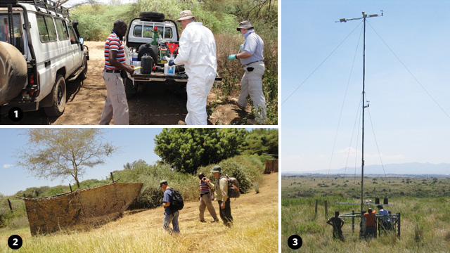
As the warnings were reaching the African countries in September and early October, continual rainfall was flooding the shallow wetlands of northeastern Africa, creating ideal habitats for the mosquitoes carrying Rift Valley fever. By mid-December 2006, Kenya had reported the first human cases of Rift Valley fever. With a lead time of three months from prediction to outcome, the 2006–2007 Rift Valley fever outbreak marked the first time that scientists were able to successfully predict an outbreak of the disease.[1. A. Anyamba et. al., “Prediction of a Rift Valley fever outbreak,” PNAS, doi: 10.1073_pnas.0806490106, 2009.]
Although this was a triumph 30 years in the making, rapidly advancing and ever-more-accessible remote-sensing technologies are making such disease-prediction models more commonplace. Similarly, specialists from a wide range of fields—from ecology and epidemiology to anthropology, marine microbiology, and animal behavior—are increasingly turning to satellite imagery to gain a more sophisticated, big-picture understanding of how organisms interact not only with their immediate environments, but also with the more expansive, global landscape. Here are some of the success stories.
Fighting Disease
The Rift Valley fever outbreak of 1997 and 1998 was among the most widespread and devastating ever recorded—infecting approximately 90,000 people and killing several hundred. Although entomologist Kenneth Linthicum, now director of the Center for Medical, Agricultural & Veterinary Entomology at the US Department of Agriculture, had used satellite data in the 1980s to demonstrate a link between increased greening of vegetation (due to rainfall) and increased prevalence of disease (due to an upsurge in mosquito populations), the predictive power of his model was nowhere near good enough to forecast the 1997 Rift Valley fever outbreak.[2. K.J. Linthicum et al., “Detection of Rift Valley fever viral activity in Kenya by satellite remote sensing imagery,” Science, 235: 1656-59, 1987.]
It wasn’t until 1999 that Linthicum, together with remote-sensing specialist Assaf Anyamba at NASA’s Goddard Space Flight Center, made the key discovery that increased rainfall, vegetation greening, and disease transmission in northeastern Africa always followed an anomalous and prolonged rise in sea-surface temperatures in the West Indian and East Pacific Oceans, associated with the warm phase of the El Niño–Southern Oscillation (ENSO).
“When these conditions converge, then you are likely to have a big epidemic,” Anyamba explains.









RSS